Duindam, D. A. (2016). Signs of the Shoah: The Hollandsche Schouwburg as a site of memory.
Retrieved from here.
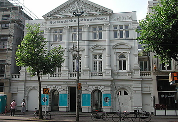
Tekenen van de Sjoa: De Hollandsche Schouwburg als een plek van herinnering bestudeert de naoorlogse ontwikkeling van de Hollandsche Schouwburg, een in situ Sjoa herdenkingsmuseum in Amsterdam. Tijdens de Tweede Wereldoorlog zijn meer dan zesenveertig duizend joden in dit voormalige theater opgesloten geweest voordat ze naar de doorgangskampen werden gedeporteerd. In 1962 opende hier de eerste nationale Sjoa herdenkingsplaats en in 1993 werd er een kleine tentoonstelling aan toegevoegd. In de lente van 2016 is het Nationaal Holocaust Museum gevestigd, dat zowel de Hollandsche Schouwburg als een nieuwe vleugel aan de overkant van de straat omvat. Ik heb onderzocht hoe deze plek van pijnlijk erfgoed een belangrijk herdenkingsmuseum werd dat gewijd was aan de herinnering van de vervolging van Nederlandse joden.
Duindam, D. A. (2016). Signs of the Shoah: The Hollandsche Schouwburg as a site of memory.
Retrieved from here.
This volume aims to demonstrate that running a shop, regulating shopping streets and shopping for pleasure in the early modern period and the nineteenth century were all social practices that took
on different forms in different times, countries and cities. Comparing them systematically from a long-term, comparative and transnational perspective, however, offers us the opportunity to trace some new and
surprising continuities and similarities, to highlight stronger contrasts and specificities, and to explore intriguing processes of cultural transfer, appropriation and exchange.
Lesger, C., & Furnée, J. H. (2014). Shopping streets and cultures from a long-term and transnational perspective: an introduction. In J. H. Furnée, & C. Lesger (Eds.), The landscape of consumption: Shopping streets and cultures in Western Europe, 1600-1900 (pp. 1-15). Basingstoke: Palgrave Macmillan.
Link: https://dare.uva.nl/search?identifier=b6a115a6-21c7-4220-9f0f-ff79f092f1b4
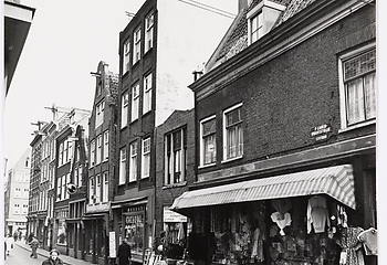
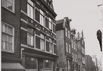
De ontwikkeling van de Amsterdamse detailhandel maakte tussen 1550 en 1850 een grote bloei door. De snelle economische en demografische expansie die aan het einde van de zestiende eeuw in Amsterdam inzette, zorgde voor grote veranderingen in het winkellandschap. In relatief korte tijd nam de vraag naar consumptiegoederen zo sterk toe dat in de stad een omvangrijke en gedifferentieerde detailhandel tot stand kwam.
Lesger, C. (2015). Waar het volk is, is de nering: bewinkelingspatroon en winkelarchitectuur in Amsterdam, circa 1550-1850. Bulletin (KNOB), 114(2), 65-83.

In Urban Europe, urban researchers and practitioners based in Amsterdam tell the story of the European city, sharing their knowledge of and insights into urban dynamics in short, thought-provoking pieces. Their essays were collected on the occasion of the adoption of the Pact of Amsterdam with an Urban Agenda for the European Union during the Dutch Presidency of the Council in 2016. The fifty essays gathered in this volume present perspectives from diverse academic disciplines in the humanities and the social sciences. The authors — including the (former) Mayor of Amsterdam, urban activists, civil servants and academic observers — cover a wide range of topical issues, inviting and encouraging us to rethink citizenship, connectivity, innovation, sustainability and representation as well as the role of cities in administrative and political networks.
Mamadouh, V., & Wageningen, A. (2016). Urban Europe. Fifty Tales of the City. Amsterdam University Press
Using data from the first land register (1832) of Amsterdam and modern gistechniques this study demonstrates that large early modern cities had more complex residential structures than small and medium sized ones. Early modern Amsterdam consisted of a mosaic of districts, each housing only part of the social pyramid (macro-segregation). Within those districts ‘around the corner’ segregation (meso-segregation) was typical. A central location, the quality of the environment and accessibility go a long way in explaining the observed patterns and they demonstrate that uni-dimensional models like the one proposed by Sjoberg in his influential study on the preindustrial city are unsatisfactory.
Lesger, C., van Leeuwen, M. H. D., & Vissers, B. (2013). Residentiële segregatie in vroeg-moderne steden: Amsterdam in de eerste helft van de negentiende eeuw. Tijdschrift voor Sociale en Economische Geschiedenis, 10(2), 102-132.
DOI: 10.18352/tseg.201
The Amsterdam was a ship of the Dutch East India Company (VOC). She was built in 1748 in Amsterdam and was lost during her maiden voyage in January 1749 near the town of Hastings on the south coast of England. Since 1984 this shipwreck has become the focal point of large scale combined underwater achaeological and historical research. Through an integrated approach this project aims to contribute to a more detailed and realistic view of the shipping and trade of the VOC in the 18th century.
Gawronski, J. H. (1990). The Amsterdam project. International Journal of Nautical Archaeology, 19(1), 53-61.
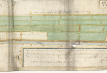
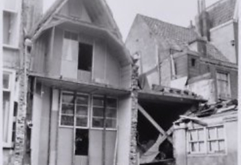
In 1452, approximately three-quarters of Amsterdam was destroyed by fire. Despite attempts by the city government to encourage citizens to build usingbrickandpantiles,thecitywasmainlyrebuiltwithtimber-framedbuildings. Onlyin1521didpetrificationofAmsterdam’sbuildingsgraduallystarttobecome more widespread, coinciding with an enormous increase in the total number of houses. The great rebuilding of Amsterdam led to a sustainable renewal of the housingstock,ofwhichsomehouseshavesurvivedtothepresentday.Thisarticle investigates the reasons for the delay in building with brick, based on building archaeologicalresearch,bylawsandinvestigationofthe1562taxregister.Itshows the mechanisms of transforming a wooden city into a brick one and reveals the effects on living conditions in the final stages of the rebuilding process in the sixteenth century.
Van Tussenbroek, Gabri. (2013). The great rebuilding of Amsterdam (1521–1578). Urban History, 1-24.
Over de datering van de vroegst bewaard gebleven huizen van Amsterdam bestaat nog veel onduidelijkheid. Zo wordt het Houten Huys op het Begijnhof kort na de stadsbrand van 1452 gedateerd. De criteria voor deze datering zijn echter discutabel. Recent dendrochronologisch onderzoek maakt nu meer duidelijk over de werkelijke ouderdom van het Houten Huys.
Van Tussenbroek, G. (2010). De datering van het Houten Huys op het Begijnhof. Nieuwe gegevens over het 'oudste' huis van Amsterdam.
Bron: Website UvA
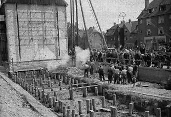
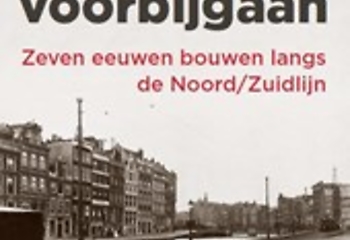
Sinds 1 april 2003 bouwt Amsterdam aan de Noord/Zuidlijn, een project dat regelmatig de landelijke pers haalt. Onderbelicht aan de bouw is dat de oude huizen en andere gebouwen van de stad hierbij blijven staan. In het kader van de aanleg van de Noord/Zuidlijn onderzocht Bureau Monumenten & Archeologie vier jaar lang de gebouwen langs de lijn tussen Centraal Station en Weteringcircuit. Gebouwen van honderden jaren oud, die sindsdien werden veranderd, getransformeerd, soms gesloopt en weer herbouwd. Het tracé langs de Noord/Zuidlijn laat zien hoe Amsterdam al honderden jaren ruimte biedt voor ontwikkeling en gebruik, zonder daarbij van zichzelf te vervreemden. Dit gebeurde ondanks ingrijpende functieveranderingen, infrastructurele maatregelen en sociale verschuivingen. De mechanismes die bij al die veranderingen van invloed zijn, worden in een inleidend essay uit de doeken gedaan. Een verrassend fotodeel toont de veranderingen die zich in de afgelopen honderdvijftig jaar hebben voltrokken. Uitgave in samenwerking met Bureau Monumenten & Archeologie, Amsterdam en de Dienst Metro van de gemeente Amsterdam.
Op 9 december hield Gabri van Tussenbroek, hoogleraar Stedelijke identiteit en monumenten aan de Universiteit van Amsterdam en bouwhistoricus bij Monumenten en Archeologie van de gemeente Amsterdam, zijn oratie ‘De mythe van de onveranderlijkheid’.
Bron: Website UvA
This article investigates the urban transformation in Amsterdam in the sixteenth century. Building archaeological and dendrochronological surveys indicate that from about 1530 on, houses were renewed, while houses from before that year are virtually absent. The year 1530 may be linked to an imperial order of 1521, in which Charles V decreed that the existing wooden buildings in Amsterdam had to be demolished and had to be replaced by stone buildings. The municipality, which since 1524 had a building supervisor, with alignment officials who came under his leadership since 1528, started to keep a building administration and formulated a comprehensive building code in 1531. The growth of the population and the resulting pressure on public space, made the city government to create space for traffic and trade. This led to modifications of roads, embankments and building blocks and inflationary rising real estate prices. For a large group of citizens who could benefit from the increasing prosperity of that time, this economical high tide was an occasion to invest in real estate, which led to a sustainable renewal of the housing stock, of which some houses have survived until the present day.
Van Tussenbroek, G. (2015). Voor de grote uitleg: Stedelijke transformatie en huisbouw in Amsterdam.
Bron: Website UvA
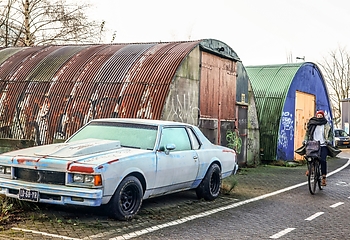
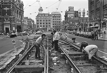
During the 1950s and 1960s, the Netherlands experienced a rapid growth in car ownership. Dutch planners and politicians soon realized that this growing automobility would radically transform the living environment, daily commute, and consumption behavior of millions of people, in particular of those living in or near large conurbations. By investigating how professional and political elites perceived increasing automobility, and how their responses subsequently affected urban planning in the Netherlands, this article offers a comprehensive and multifaceted narrative of the dawning of the Dutch motor age. I demonstrate how the gloomy and fearful predictions of planners and traffic engineers working in the 1960s foreshadowed a wider discontent with car-centered planning. Their engagements with local officials and urban action groups led to planning compromises I describe as a form of “gentle modernization,” typical for a country which has always opted for a cautious approach to modernity.
Verlaan, T. (2019). Mobilization of the Masses: Dutch Planners, Local Politics and the Threat of the Motor Age 1960-1980. Journal of Urban History. https://doi.org/10.1177/0096144219872767
During the first post-war decades, Amsterdam's inner city was under threat. City officials, planners and private developers considered the comprehensive redevelopment of central districts as the only solution to accomodate a growing population. In the second half of the 1960s, residents rose up against this urban renewal order. This contribution takes discussions over the future of Amsterdam's Leidseplein as a case study.
Verlaan, T. (2016). Delivering for the fancy as well as the shabby: Amsterdam's postwar utopia of urban diversity. Joelho, 7, 16-27.
DOI: https://doi.org/10.14195/1647-8681_7_1
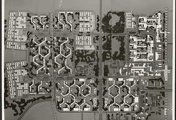
The plans for the two largest and most important post-war urban expansions of Amsterdam, the Bijlmermeer (1965) and new town Almere (1971), were developed within a time span of only a few years, but their architecture and design layout could not be more different. Both have been subject of extensive regeneration policies. This article demonstrates how the professional views on the Bijlmer and Almere and the images brought about by policy makers interacted and correlated with each other, and how these have strongly influenced the composition of the regenaration schemes that have been developed over the last two decades.
Brouwer, P., & Verlaan, T. (2013). Symbolic gestures? Planning and replanning Amsterdam's Bijlmermeer and new town Almere since 1965. Informationen zur modernen Stadtgeschichte, 2013(1), 48-59
LInk: https://difu.de/publikationen/2013/westeuropaeische-grosssiedlungen.html