
As part of our Amsterdam for All project, we explored existing tools that deliver or help deliver city-related accessibility information to the citizens. The objective of this analysis was to get to know what problems are already being solved, the target groups, the overlaps, and the geographical coverage. In this blog post, we share some of the tools that we found useful.
1. The Euan’s Guide
The Euan’s Guide is an access website for people with disabilities to discover, share and review new and, most importantly, accessible places to go. The website can help in deciding where to go by removing the fear of the unknown or long hours of web research and phone calls before visiting somewhere new.

Bron: Amsterdam Inteligence
People with disabilities, their family, friends, and carers can find and leave reviews on the transport possibilities, parking possibilities, access, toilets, and staff. The users can find on each filled-in profile ratings, detailed explanations, and pictures for the searched venue. At the beginning of each review, it is also mentioned for which target group the review is relevant.
Euan’s guide was launched by Euan MacDonald (electric wheelchair user) and his sister, who have an award-winning charity based in Scotland. Euan’s guide is meant to have reviews from worldwide places, however, it has a wider coverage in the UK.
2. iAccess Life
IAccess Life is a mobile app (App Store, Google Play) created for people with disabilities, especially for wheelchair users and users of mobility aids, to share their experiences wherever they have been across the world. With that information, others can quickly explore places where they would like to go.
The mobile app allows the users to search per category within a radius of a current location. Users can rate the entrance, bathroom, parking, and interior of each establishment and leave a comment.

Bron: Amsterdam Intelligence
Altogether, IAccess life enables users to plan their trip by searching for all needed commodities on their route that fit their needs, such as restaurants, hotels, and supermarkets.
3. Wheelmap
Wheelmap is an online worldwide map for finding and rating wheelchair-accessible places. The map can be accessed at wheelmap.org or via a mobile application (App Store, Google Play). It has rated places in 30 countries and is available in 32 languages.
Wheelmap uses a simple traffic light system to allow users to identify the accessibility level of public places from the map view. It is possible to filter by category and accessibility level. In addition, users can also add ratings themselves.

Bron: Amsterdam Intelligence
The amount of rated places varies between cities and countries, since, as the tools mentioned above, Wheelmap is dependent on the partners and contributions from the community.
4. Google Maps
A well-known map within the west; Google Maps is a navigation tool used, as of 2020, by over 1 billion people every month worldwide [1]. This tool offers detailed routes, directions, and time predictions across different ways of transportation. Unfortunately, the shortest routes are not always the best for everyone, therefore, Google Maps is introducing Accessible Places and Wheelchair-Accessible Routes to become more wheelchair-friendly.
Bron: Amsterdam Intelligence
Accessible places allow the users to turn on accessibility settings, and a wheelchair icon will show up in the overview of an establishment. They will be able to see in the details if it has accessible seating, parking, restroom, and entrance. However, currently, this functionality is only available in the United Kingdom, the United States, Australia, and Japan.

Bron: Amsterdam Intelligence
Wheelchair-Accessible routes aim to offer wheelchair users information about accessible public transportation. It can be activated in the options menu, and it filters routes that are accessible by wheelchair.
5. HogeNood
HogeNood is a mobile app (App Store, Google Play) for anyone to find a toilet in the city based on previous assessments, distance, and facilities. The app provides information about available toilets within cities across the Netherlands and Belgium.

Bron: Amsterdam Intelligence
The HogeNood app provides information about the current distance to the toilet if it is accessible for men, women, babies, and wheelchair users. You can also find the business hours, the existence of a fee, and reviews from previous visitors.
Hogenood has more than 300 partners (municipalities and companies) to stay in contact with the toilets’ owners and give accurate and up-to-date information.
6. BlindSquare
BlindSquare is a paid mobile navigation app, only available for IOS, that helps blind, deafblind, and partially sighted people navigate indoors and outdoors through a voice-over. This app can also be controlled by voice command, offered as a premium service.
Next to the voice-over navigation, the users can also get information about the current location, existing establishments nearby, add favorites, and link it with their social media accounts. The BlindSquare is now available in 25 languages.
7. Accessmap
Accessmap is a mapping application that assists wheelchair users and users of mobility aids, in planning their routes based on the steepness of the streets and specific profiles. It is currently available in Seattle, Bellingham, and Mt. Vernon.

Bron: Amsterdam Intelligence
With this tool, the users can do route planning, verify the steepness and get the directions. The route is calculated based on the selected profile. There are three default profiles (user of a crutch, manual wheelchair, and electric wheelchair), but it is also possible to create a custom one with specific needs.
8. Project Sidewalk
Project Sidewalk is a web-based labeling tool initiated by the University of Washington with pilots in the US and Mexico. It enables crowd workers to remotely label street-level accessibility features, such as curb ramps, obstacles, sidewalks, crosswalks, and traffic signals. This is done through a virtual walkthrough in Google Street View that shows different views of the city streets.
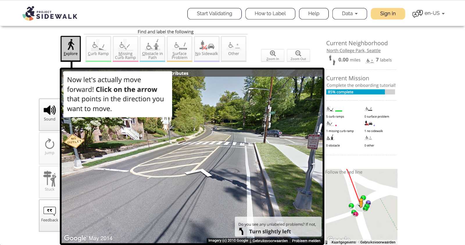
Bron: Amsterdam Intelligence
Next to labeling, Project Sidewalk offers more functionalities, such as label validation, tutorials, and result maps with an overview of the accessibility status of different neighborhoods. All this information is very useful for navigation purposes but also for the municipalities to have an overview of the accessibility of the streets, what is missing, and prioritize interventions.
It is our mission, as Amsterdam Intelligence, to measure accessibility in the city, therefore, we will start a pilot at the beginning of this year with Project Sidewalk. During this pilot, the platform will be fully translated to Dutch and will be open to anyone who wants to help us out with labeling. Stay tuned for more details on this topic!
9. Open Sidewalks
Open Sidewalks is not a citizen-facing tool but instead, it is an enabler. This project aims to map sidewalks in a standardized way. Currently, there are extensive open data available on transportation networks, but the sidewalks have been generally treated as an addendum to streets. Therefore, Open Sidewalks proposes to generate an Open Street Maps-based pedestrian network with global coverage, which can feed the right information to already existing applications that help people with disabilities (e.g. BlindSquare).
Conclusion
Altogether, this research provided insights on the variety of use cases and existing tools regarding collecting and sharing accessibility in the city. The amount of work these companies and organizations have already done and the momentum they have achieved is impressive.
We observed that there is yet more focus on establishments accessibility than pedestrian accessibility. Also, during interviews with citizens we found out that the existence of many tools with the same or similar functionalities makes information scattered, which harms findability and discourages continued use. Taking this into account, our goal should not be to create just more apps but to explore the existing needs, collect the right data, and share that information with existing tools. In the end, we want to inform city officials and make Amsterdam citizens be heard and have their daily lives enabled.
References
[1] "Google Maps Metrics and Infographics - Google Maps for iPhone". sites.google.com. Retrieved April 1, 2021.
Auteur: Cláudia Pinhão
Dit artikel is afkomstig van de website van Amsterdam Intelligence