According to recent research, 16% of the people between 16 and 65 in Amsterdam have low literacy skills. This hinders societal participation in tasks such as voting, paying taxes, reissuing documents, or applying for social benefits. Thus, as part of our Amsterdam for All project, we have set on a mission to research the use of AI for measuring and improving the readability of municipal communication.
Dit project heeft als doel om innovatieve oplossingen en interventies te ontwikkelen die de toegankelijkheid en mobiliteit voor alle bezoekers en bewoners van Amsterdam kunnen verbeteren.
Beschrijving
In het project "Social Mobility" richten we ons op zowel de toegankelijkheid van openbaar vervoer als op de huidige stedelijke infrastructuur die het gebruik ervan toegankelijk maakt. Dat wil zeggen, de stedelijke infrastructuur die een gemakkelijke toegang mogelijk maakt tussen verschillende punten in de stad te voet, met een rolstoel, scootmobiel, enzovoort. In dit project willen we data en kunstmatige intelligentie (AI) gebruiken om de toegankelijkheid van de stad in kaart te brengen en te verbeteren.
Het verbeteren van de toegankelijkheid is een belangrijk aspect van de Amsterdamse visie. Om dit te bereiken, voeren we een reeks experimenten en interventies uit gericht op het meten en verbeteren van de toegankelijkheid en algehele mobiliteit van de stad. Ons doel is om stadsbestuurders te voorzien van tijdige, accurate gegevens en analyses, zodat ze weloverwogen beslissingen kunnen nemen op basis van tastbaar bewijs. Uiteindelijk is ons doel om een breed scala aan belanghebbenden in staat te stellen om inclusiviteit en toegankelijkheid voor alle bezoekers en inwoners van Amsterdam te bevorderen.
Doelstelling
Het algemene doel van het project is om innovatieve oplossingen en interventies te ontwikkelen die de toegankelijkheid en mobiliteit voor alle bezoekers en bewoners van Amsterdam kunnen verbeteren. Bijvoorbeeld het integreren van een routeplanner en een inclusief MaaS-systeem. Met toegankelijkheidsinformatie zullen gebruikers eerder gebruik maken van het openbaar vervoer dan van AOV (aanvullend openbaar vervoer).
Looptijd
2023 - 2024 (verwacht)
Opdrachtgevers
Debbie Dekkers (Smart Mobility Team - Stedelijke Innovatie en R&D)
Samenwerking met V&OR, World Enabled, Cliëntenbelang, Vervoerregio.
EU Horizon PEER project: Multi-objective route planner
Het PEER project is een Europese samenwerking waarbinnen mens-AI interactie onderzocht wordt met als doel de gebruiker centraal te stellen, transparantie te vergroten, en de AI oplossing personaliseerbaar te maken. Binnen Amsterdam richten we ons op een toegankelijke routeplanner voor mensen met mobiliteitsbeperkingen.
Beschrijving
Het hyPEr ExpeRt collaborative AI assistant (PEER) project is een door het EU Horizon programma gefinancierd project waarin we samenwerken met academische en industriële partners. Het doel van het project is om de gebruiker centraal te stellen bij zowel het ontwerp als ook de ontwikkeling, implementatie en evaluatie van AI-systemen. Hierdoor wordt echte samenwerking tussen mens en AI mogelijk. Het project richt zich op de toepassing van AI in complexe sequentiële besluitvormingsproblemen.
Specifiek zal de stad Amsterdam zich richten op de creatie van een zeer personaliseerbare toegankelijke routeplanner, waarin burgers routes door Amsterdam kunnen vinden die zijn afgestemd op hun individuele toegankelijkheidsbehoeften en -voorkeuren. Dit valt binnen ons bredere doel om de stad toegankelijk te maken voor alle burgers, als onderdeel van het Amsterdam for All project.
In Amsterdam zullen we een prototype routeplanner creëren, mede-ontworpen met eindgebruikers die behoefte hebben aan toegankelijke routes. Bovendien zullen we een API creëren die toegankelijkheidsinformatie over mogelijke routes in Amsterdam publiekelijk beschikbaar stelt. Onze academische partners zullen helpen bij het identificeren van de juiste functionaliteit voor nieuwe algoritmen die ze zullen ontwikkelen voor personaliseerbare en uitlegbare AI. Dit met als doel om de gebruikers in staat te stellen om de juiste adviezen te krijgen van de toegankelijke routeplanner, wanneer we deze algoritmen integreren in ons prototype.
Doelstelling
Het is onze hoop dat een personaliseerbare routeplanner de stad toegankelijker maakt voor iedereen. Het gaat hierbij om een prototype, waarmee we willen aantonen dat het mogelijk is om inclusieve routeplanners aan te bieden. Door hierbij aansluiting te zoeken met lokale partners willen we momentum genereren. Voor evaluatie werken we nauw samen met organisaties zoals Cliëntenbelang.
Binnen dit project zullen we volledig open source ontwikkelen, rekening houdend met eventuele privacy-gevoeligheid van data. Hierdoor zullen onze resultaten optimaal gedeeld kunnen worden. Datzelfde geldt voor de methodologie rondom de mens-AI interactie, die in de toekomst steeds relevanter zal worden.
Looptijd
Oktober 2023 – September 2027
Opdrachtgevers
Stedelijke Innovatie en R&D
EU Horizon project met meerdere partners:
Gemeente Amsterdam, Afdeling Innovatie
Vrije Universiteit Brussel (Coördinator)
Fujitsu Services Gmbh
Centre Aquitain des Technologies del'Information et Electroniques (CATIE)
Instituto de Engenhariade Sistemas e Computadores, Tecnologia e Ciencia (INESC TEC)
Fundacio Eurecat
Alpha Consultants s.r.l.
Technische Universiteit Eindhoven (TU/E)
Univerzita Karlova
Uniwersytet Jagiellonski
MC Shared Services S.A. - Sonae
Proditec
Continental Engineering Services Portugal Unipessoal lda.
The municipality of Amsterdam has the ambition to offer its citizens as much independent and equal participation as possible. However, people with disabilities face a wide variety of barriers when moving or participating in the city. Advances in artificial intelligence offer opportunities to improve the accessibility of the city.
Recent studies suggest that 25% of all people in cities encounter barriers based on age or disability. With the right partnerships and tools, we can accelerate the development and implementation of new urban technology and G2G solutions at scale. This paper presentation describes several research projects, such as a collaboration with World Enabled.
A Q&A will follow after the paper presentation (starting at 10:30).
Due to technical difficulties the beginning of the presentation hasn't been recorded.
On March 3, 2022, Amsterdam, together with World Enabled, launched the Amsterdam for All project. Speakers are Maarten Sukel, Dr. Victor Pineda and Dr. Jon Froehlich.
In this project, the inclusive accessibility of the city is measured by means of artificial intelligence; for example, on which sidewalks there are obstacles and where there is a lowered pedestrian crossing - useful for communication about the accessibility of shopping streets and restaurants. In this way, the project contributes to an inclusive city, accessible to all Amsterdammers. You can watch the recording of the launch below.
AI wordt ingezet voor de verbetering van toegankelijkheid in Amsterdam
Voor velen van ons zijn dagelijkse activiteiten vanzelfsprekend. Zoals zelfstandig het openbaar vervoer nemen, wandelen in het centrum van de stad, toegang krijgen tot online diensten of naar een restaurant gaan. Helaas is dat niet voor iedereen het geval. De gemeente Amsterdam heeft de ambitie om een vrije, rechtvaardige en duurzame stad voor alle burgers te maken. Toegankelijkheid speelt hierin een grote rol. In dit artikel geven we inzicht in de projecten en AI oplossingen op het gebied van toegankelijkheid door middel van het Amsterdam for All initiatief.
Bron: Pexels
Amsterdam for All
Amsterdam for All bestaat uit een reeks experimenten om de bereikbaarheid en toegankelijkheid van de stad te meten. Hiermee geven we ambtenaren de juiste gegevens en analyses, zodat ze hun beslissingen kunnen baseren op tastbaar bewijs. Daarmee wordt het leven voor iedereen in de stad toegankelijk gemaakt.
Het uiteindelijke doel van het AI team is om door middel van goed ontworpen en geïmplementeerde producten, diensten, omgevingen en apparatuur het leven van mensen met een beperking makkelijker te maken. Wij geloven dat het mogelijk moet zijn voor mensen met een beperking om te genieten van dagelijkse activiteiten met dezelfde inspanning als mensen zonder beperking. Door het meten van toegankelijkheid in de stad verkennen we de problemen waar burgers en organisaties tegenaan lopen. Aan de hand hiervan stellen we prioriteiten en creëren we AI gerelateerde oplossingen.
Bron: www.amsterdamintelligence.com
Stoepen, fietsen en andere lastige objecten
Mensen met een beperking hebben vaak problemen met obstakels op de stoep. Dit komt vanwege de te lange oversteekplaatsen of ontbrekende opritten. Ook ontbrekende markeringen en te hoog geplaatste drukknoppen zijn een probleem. Hierdoor kunnen ze hun dagelijkse activiteiten niet op dezelfde manier uitvoeren als mensen zonder beperking.
Fietsen zijn een ander relevant knelpunt voor de toegankelijkheid doordat ze bij het blokkeren van de weg een gevaar vormen. Door gebruik te maken van historische tellingen van het aantal obstakels op trottoirs (bv. fietsen), is het mogelijk om aan de hand van de kenmerken van de straat of buurt te voorspellen hoe groot de kans is dat er obstakels op de stoep zullen zijn. De nabijheid van een café of school kan de aanwezigheid van fietsen verklaren. Hoe kunnen we de aanwezigheid of afwezigheid van dergelijke kenmerken in kaart brengen?
Toegankelijkheid in kaart brengen
Het in kaart brengen van toegankelijkheidsobstakels kan een uitdagende taak zijn. Een oplossing is de start van Project Sidewalk. Dit is een systeem die de straten van een stad virtueel verkennen en de informatie daarvan in kaart brengt. Een soortgelijke aanpak is het nemen van luchtfoto’s met lidar-gegevens. Lidar-gegevens worden gebruikt om de hoogte van bijvoorbeeld troittoirs nauwkeirig te meten, en luchtfotos worden gebruikt om oversteekplaatsen te bepalen. Het AI team concludeerde dat we met panoramabeelden het bestaan of ontbreken van voetgangerskenmerken konden vaststellen. Enkele voorbeelden van voetgangerskenmerken zijn obstakels, opritten, oversteekplaatsen, drukknoppen, tactiele markeringen en straatmeubilair. Toch blijft het een hele opgave om nauwkeurige metingen en tijdsvoorspellingen te doen op basis van panoramabeelden. Dit geldt ook voor de toegankelijkheid van gebouwen, niet-visuele informatie en het contrast van trottoirs en borden.
Tot zo ver..
Helaas weten mensen met een beperking vaak niet van tevoren of zij gebruik kunnen maken van een openbaar gebouw. Toegankelijkheidsinformatie over openbare gelegenheden wordt vaak handmatig ingevoerd, waardoor er voor veel gebieden in de stad informatie ontbreekt. Het gevolg hiervan is dat burgers naar een locatie gaan om er vervolgens achter te komen dat hun toegang onmogelijk is. Wij denken dat het herkennen van bepaalde toegankelijkheidsrichtlijnen kan worden gedaan aan de hand van bestaande beelden, en we zouden deze beoordelingen automatisch aan plaatsen kunnen geven. Dit zou bezoekers in staat stellen snel na te gaan welke faciliteiten worden aangeboden voor een groot aantal plaatsen. Tegelijkertijd zou het de stad in staat stellen te controleren welke plaatsen toegankelijk zijn, na te gaan of het in de loop der jaren beter gaat en beleid te maken op basis van de verzamelde informatie. Op deze manier hopen we een stad te vormen die voor iedereen toegankelijk is.
Velen van ons beschouwen dagelijkse activiteiten zoals zelfstandig het openbaar vervoer nemen, wandelen in het stadscentrum, toegang krijgen tot online diensten of naar een restaurant gaan als vanzelfsprekend. Helaas is dat niet voor iedereen het geval. Amsterdam heeft de ambitie om iedere burger dezelfde rechten te bieden. Daarom zet Amsterdam Intelligence samen met de gemeente Amsterdam zich in voor de verbetering van toegankelijkheid. Toegankelijkheid is een vaak verkeerd gebruikte term en het omvat een enorme hoeveelheid verschillende onderwerpen en mensen. Daarom kan het al snel een overweldigend onderwerp worden . In dit artikel legt Cláudia Pinhão uit wat een stad toegankelijk maakt, wie het dient, en hoe we kunnen bijdragen met behulp van AI.
Source: Amsterdam Intelligence
Many of us take for granted daily activities such as independently taking public transport, walking in the city center, accessing online services, or going to a restaurant. Unfortunately, this is not the case for everyone. As a city, we have the ambition to offer the same rights to every citizen.
Accessibility is a commonly misused term and it comprises an enormous amount of different subjects and people. Therefore, it can quickly become an overwhelming topic. The last thing we should want is to make accessibility inaccessible by itself. We believe there is a lot that can be improved using AI, but before jumping into solutions, it is crucial to understand what makes a city accessible, whom it serves, and how we can contribute. Here are some steps I suggest to approach the topic.
“Accessibility means that a product or service can be used by everyone, including people with disabilities. Product has a broader meaning here and includes buildings, transportation facilities, ATMs, utensils such as telephones, computer programs and websites.”
The goal is to empower individuals and enable independent living through well-designed and implemented products, services, environment, and devices. People with disabilities should perform and complete their daily activities in a similar amount of time and effort as any other person without disabilities.
We cannot state a building is accessible because it has ramps, or that a website is because blind people can use it. Different people will have distinct requirements and accessible is meant to include everyone.
Source: Amsterdam Intelligence
The disability is on the environment
In the early ’90s, the terminology handicapped was substituted by ‘people with disabilities'. Victor Pineda in‘Building Cities for All Training program’defines disability as:
“A person that has, either a long term physical, mental, intellectual, sensory impairment, which in interaction with various barriers, experiences some type of limitation of their participation.”
The new term shifts the pressure away from the people and places it on the environment. The disability refers to the interaction between the environment and the individual. It is up to the environment to create new ways for everyone to feel included. Inclusivity then becomes the most used term. We must progress towards a single solution that fits everyone as much as possible.
Source: Amsterdam Intelligence
Broad scope
Making a city accessible covers many different dimensions. Pineda’sIceberg of Inequality modelpresents nine policy dimensions, divided intobasic freedoms(represent basic needs) andbasic functionings(turn basic freedoms into capabilities). His theory aims to help initiate cross-sectoral reforms in an attempt to improve social justice, equity, and progress for people with disabilities¹.
Pineda's “Iceberg of Inequality” that features basic functioning and basic freedoms. Source: Amsterdam Intelligence
As we can see, a city won’t become accessible only because it has enough curb ramps or audible beacons. It requires a synergy between different fields, where people with disabilities are also heard, supported, and able to participate. Among others, we have to rethink our built environment, public spaces, transportation, ways of communication, services, and public facilities to enable life. A right that everyone should have.
2. Collaboration is key
About 1 in 8 people live with a disability in the Netherlands². There are numerous types of disabilities and combinations. Something that is accessible for someone can be entirely inaccessible for another.
No one can better identify a problem and help coming up with solutions than residents living with disabilities, representative organizations, and field experts.
It is of uttermost importance to include them in debates, workshops, project development, and tests.
3. Being aware of the limitations
A 100% accessible city might be unattainable. These are some of the limitations I have encountered:
Different people can have contradicting requirements;
Some situations can be overlooked because of unawareness;
Different disability types might have an unbalanced representation which reflects on the existing policies;
Amsterdam areas, such as the old center that dates from the 17th century³, presents an urban pattern that challenges the possibility of good accessibility.
Acknowledging the limitations is crucial to understand what can be done. We have to take one step at a time towards a city as accessible as possible.
4. Basing decisions on tangible evidence
New standards and laws are being created. But how can we measure if accessibility is actually delivered? There is no current way to measure accessibility in the city.
We need tangible evidence to compare outcomes and identify existing bottlenecks.
With this, city officials will be able to make informed decisions and share countable results.
Source: Amsterdam Intelligence
Next steps
We believe Amsterdam Intelligence can play an extensive role in helping to measure accessibility in the city. Together with city officials, organizations and citizens, we are exploring the problems, prioritizing, and, soon, creating solutions.
Firstly, we will be focusing on pedestrian mobility that targets obstructions, pathways, curb ramps, pedestrian crossings, street furniture, signage, parking, and stops and stations. Stay tuned for new developments!
Using Artificial Intelligence to measure accessibility
De gemeente Amsterdam heeft de ambitie om haar burgers zo veel mogelijk een onafhankelijke en gelijkwaardige participatie te bieden. Mensen met een beperking ondervinden echter een grote variatie aan belemmeringen bij het zich verplaatsen in of het actief deelnemen aan de stad. De recente vooruitgang op het gebied van kunstmatige intelligentie kan volgens ons van cruciaal belang zijn bij het vinden en oplossen van deze knelpunten. Om een zinvolle, nuttige en bruikbare toepassing van AI te garanderen, is het team van Amsterdam Intelligence een samenwerking aangegaan met World Enabled. In dit artikel leggen Maarten Sukel en Cláudia Pinhão uit hoe ze verschillende onderzoeksrichtingen hebben gekozen en waarom ze denken dat ze nuttig kunnen zijn.
The City of Amsterdam has the ambition to offer its citizens independent and equal participation as much as possible. However, people with disabilities encounter a high variety of barriers when moving around or participating in the city. We believe recent advancements in artificial intelligence can be crucial in finding and solving these bottlenecks. To guarantee a meaningful, useful and usable application of AI, we have partnered with World Enabled, who will guide us through the process.
"Recent studies suggest that 25% of all people encounter barriers in cities based on age or disability. With the right partnerships and tools we can accelerate the development and deployment of new urban tech and G2G solutions at scale. We look forward to embarking on this journey and leveraging the combined technical capabilities of Intelligent Amsterdam and World Enabled. - Dr. Victor Pineda, President of World Enabled
The advancements in the field of Artificial Intelligence potentially open up a whole range of new possibilities in tackling this topic, allowing for new ways to measure accessibility with a generic and scalable approach. Over the past months, we have been talking to experts about city design, diversity and inclusion to find out which problems need to be tackled.
In the next few years, we will be using the powers of Artificial Intelligence to help cities become more accessible. In this blog post, we will describe how we chose the different research directions, possible ways to tackle them, and why we think they can be beneficial.
Choosing the topics
To kick start this topic, together withWorld Enabled, we have gathered an international team of accessibility experts in a workshop to understand which accessibility-related information could be extracted from street panorama images (collected every year by the City of Amsterdam and saved after removing privacy sensitive information such as license plates and people). The experts were divided into three groups and we asked them to:
Annotate the selected images with a red sticky note for bad accessibility practices and a green sticky note for good practices, writing down their explanation.
Identify what type of accessibility-related information is missing on the city panorama images.
Remote workshop exercises on Miro. Source: Amsterdam Intelligence
We concluded that panorama images could allow us to identify the existence or lack of pedestrian features, such as obstacles, curb ramps, crossings. push buttons, tactile markings, street furniture, between others. However, precise measurements, time predictions, non-visual information, buildings accessibility and the contrast of pavements and signs cannot be evaluated from street view panorama images alone, due to visual properties or the dynamic lighting of the images.
Workshop results that answer ‘what could we identify with panorama images?’ Source: Amsterdam Intelligence
Workshop results that answer ‘what can’t we identify with panorama images?’ Source: Amsterdam Intelligence
This workshop allowed us to understand the broad spectrum of measuring accessibility for pedestrian mobility, for which many data sources are required. To prioritize and define our research directions we followed the following methodology:
Collected the accessibility guidelinesfor designing a barrier-free public space, from the municipality of Amsterdam and United Nations Enabled;
Combined the resultsof the workshop and the accessibility guidelines, categorized and described each accessibility-related feature;
Created a survey for accessibility expertsto measure the level of impact for each feature. By high impact, we meant the features that answer the need of most disability types and/or the pain points more often reported;
Created a survey for data scientiststo measure feasibility, regarding the available datasets;
Prioritized based on the surveys’ results.We selected the city features evaluated with the highest impact and feasibility.
People with disabilities frequently have trouble with obstacles on the sidewalk; crosswalks that are too long; missing curb ramps; missing tactile markings; press buttons positioned too high. These don’t allow them to proceed with their daily activities the same way people without disabilities do. So how could we map the presence or absence of such features?
It can be a challenging task to map accessibility obstacles. Fortunately, systems likeproject sidewalkallow us to virtually explore the streets of a city and label this type of information. Similar approaches could be done usingaerial imagesorlidar data. Aerial data can, for example, be used to locate crosswalks and Lidar data to measure the height of sidewalks accurately.
In the end, the collected data can be used to automatically detect these features in the whole city using computer vision techniques. Thus, this could result in a method for regularly measuring accessibility in a cost-effective way and on a large scale.
The applications of this data could feature both city officials and citizens. On one hand, we could give city officials updates on the city’s changing accessibility levels and identify which areas still need attention. On the other hand, we could add an extra layer of information to existing route planning systems, so they could offer more personalised routes to citizens.
Bicycle count prediction
Bicycles are another relevant accessibility bottleneck mentioned in our surveys, very characteristic of Amsterdam. Even though bicycles are considered temporary obstacles, they are still obstacles that can delay, block or be a hazard, especially for people with disabilities.
The dynamic nature of bicycles makes them harder to detect. However, by using historical counts of the number of obstacles on sidewalks (e.g. bicycles), it could be possible to use the characteristics of the street or neighbourhood to predict how likely it is that there will be obstacles on the sidewalk. The proximity of a bar would explain the presence of bikes during the evening, and a school would have more bikes parked during working hours.
The benefits of predicting the positioning of such obstacles can be twofold. On one hand, we can help city officials to identify busy areas of the city. With that information they can make informed decisions, as for example, add more bicycle parking in certain areas. On the other hand, we could add an extra layer of information to existing route planning systems, so they could offer more personalised routes to citizens, where they can avoid temporary obstacles or at least be aware of them.
Venue accessibility assessment
Unfortunately, people with disabilities (especially wheelchair users) frequently do not know if they can use a public building beforehand. Accessibility information about public venues is often entered manually, so there is missing information for plenty of areas in the city. As a result, citizens can end up going to a venue only to figure out that their entrance is impossible.
Some platforms offer information about the accessibility of certain venues. For example, onwheelmapyou can find information about wheelchair ramps and accessible toilets. Even though it is a great initiative, it is limited by users entering this information. Another example is street view images, where it is possible to look at a certain venue and check if the door is wide enough. However, this still needs to be done manually, by the user. All these tasks could be replaced by computer vision techniques.
We believe that recognizing certain accessibility guidelines can be done through existing images, and we could give these ratings to places automatically. This would allow visitors to quickly verify what facilities are offered for a large quantity of venues. At the same time it would allow the city to monitor which venues are accessible, check if it is improving over the years, and allow the creation of policy based on the collected information.
Conclusion
In the next few years we will be working on these challenges, and while we do this we will continue to describe how it is going and what new insights have been generated. We do think that these are all promising new applications of AI, and hope that measuring accessibility with these types of techniques will eventually make the city accessible for all.
"The Amsterdam for All initiative developed in partnership with World Enabled will effectively leverage the powers of emerging technologies to address data gaps and unlock new and compelling solutions to a variety of access and inclusion barriers in the city. " - Ger Baron, CTO City of Amsterdam
Als onderdeel van ons Amsterdam for All-project heeft het team van Amsterdam Intelligence bestaande tools onderzocht die toegankelijkheidsinformatie van de stad aan de burgers leveren of helpen leveren. Het doel van deze analyse was om te weten te komen welke problemen al worden opgelost, de doelgroepen, de overlappingen en de geografische dekking. In dit artikel, geschreven door Cláudia Pinhão, lees je meer over de handige tools die beschikbaar zijn.
As part of ourAmsterdam for Allproject, we explored existing tools that deliver or help deliver city-related accessibility information to the citizens. The objective of this analysis was to get to know what problems are already being solved, the target groups, the overlaps, and the geographical coverage. In this blog post, we share some of the tools that we found useful.
1. The Euan’s Guide
TheEuan’s Guideis an access website for people with disabilities to discover, share and review new and, most importantly, accessible places to go. The website can help in deciding where to go by removing the fear of the unknown or long hours of web research and phone calls before visiting somewhere new.
Bron: Amsterdam Inteligence
People with disabilities, their family, friends, and carers can find and leave reviews on the transport possibilities, parking possibilities, access, toilets, and staff. The users can find on each filled-in profile ratings, detailed explanations, and pictures for the searched venue. At the beginning of each review, it is also mentioned for which target group the review is relevant.
Euan’s guide was launched by Euan MacDonald (electric wheelchair user) and his sister, who have anaward-winning charitybased in Scotland. Euan’s guide is meant to have reviews from worldwide places, however, it has a wider coverage in the UK.
2. iAccess Life
IAccess Lifeis a mobile app (App Store,Google Play) created for people with disabilities, especially for wheelchair users and users of mobility aids, to share their experiences wherever they have been across the world. With that information, others can quickly explore places where they would like to go.
The mobile app allows the users to search per category within a radius of a current location. Users can rate the entrance, bathroom, parking, and interior of each establishment and leave a comment.
Bron: Amsterdam Intelligence
Altogether, IAccess life enables users to plan their trip by searching for all needed commodities on their route that fit their needs, such as restaurants, hotels, and supermarkets.
3. Wheelmap
Wheelmap is an online worldwide map for finding and rating wheelchair-accessible places. The map can be accessed atwheelmap.orgor via a mobile application (App Store,Google Play). It has rated places in 30 countries and is available in 32 languages.
Wheelmap uses a simple traffic light system to allow users to identify the accessibility level of public places from the map view. It is possible to filter by category and accessibility level. In addition, users can also add ratings themselves.
Bron: Amsterdam Intelligence
The amount of rated places varies between cities and countries, since, as the tools mentioned above, Wheelmap is dependent on the partners and contributions from the community.
4. Google Maps
A well-known map within the west;Google Mapsis a navigation tool used, as of 2020, by over 1 billion people every month worldwide [1]. This tool offers detailed routes, directions, and time predictions across different ways of transportation. Unfortunately, the shortest routes are not always the best for everyone, therefore, Google Maps is introducing Accessible PlacesandWheelchair-Accessible Routesto become more wheelchair-friendly.
Bron: Amsterdam Intelligence
Accessible places allow the users to turn on accessibility settings, and a wheelchair icon will show up in the overview of an establishment. They will be able to see in the details if it has accessible seating, parking, restroom, and entrance. However, currently, this functionality is only available in the United Kingdom, the United States, Australia, and Japan.
Bron: Amsterdam Intelligence
Wheelchair-Accessibleroutes aim to offer wheelchair users information about accessible public transportation. It can be activated in the options menu, and it filters routes that are accessible by wheelchair.
5. HogeNood
HogeNoodis a mobile app (App Store,Google Play) for anyone to find a toilet in the city based on previous assessments, distance, and facilities. The app provides information about available toilets within cities across the Netherlands and Belgium.
Bron: Amsterdam Intelligence
The HogeNood app provides information about the current distance to the toilet if it is accessible for men, women, babies, and wheelchair users. You can also find the business hours, the existence of a fee, and reviews from previous visitors.
Hogenood has more than 300 partners (municipalities and companies) to stay in contact with the toilets’ owners and give accurate and up-to-date information.
6. BlindSquare
BlindSquareis a paid mobile navigation app, only available forIOS, that helps blind, deafblind, and partially sighted people navigate indoors and outdoors through a voice-over. This app can also be controlled by voice command, offered as a premium service.
Next to the voice-over navigation, the users can also get information about the current location, existing establishments nearby, add favorites, and link it with their social media accounts. The BlindSquare is now available in 25 languages.
7. Accessmap
Accessmapis a mapping application that assists wheelchair users and users of mobility aids, in planning their routes based on the steepness of the streets and specific profiles. It is currently available in Seattle, Bellingham, and Mt. Vernon.
Bron: Amsterdam Intelligence
With this tool, the users can do route planning, verify the steepness and get the directions. The route is calculated based on the selected profile. There are three default profiles (user of a crutch, manual wheelchair, and electric wheelchair), but it is also possible to create a custom one with specific needs.
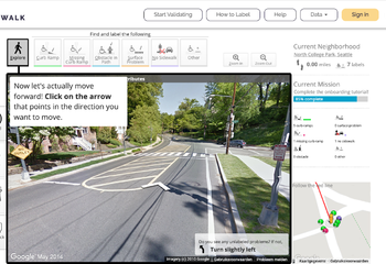
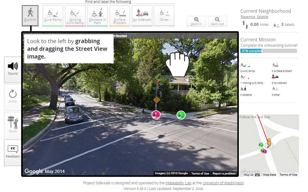
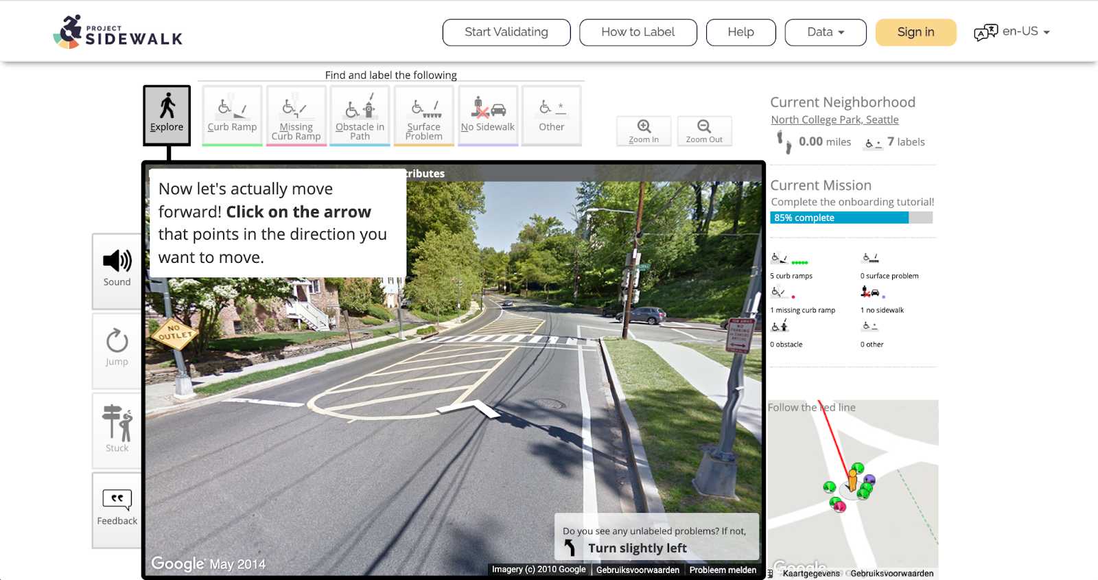
8. Project Sidewalk
Project Sidewalkis a web-based labeling tool initiated by the University of Washington with pilots in the US and Mexico. It enables crowd workers to remotely label street-level accessibility features, such as curb ramps, obstacles, sidewalks, crosswalks, and traffic signals. This is done through a virtual walkthrough in Google Street View that shows different views of the city streets.
Bron: Amsterdam Intelligence
Next to labeling, Project Sidewalk offers more functionalities, such as label validation, tutorials, and result maps with an overview of the accessibility status of different neighborhoods. All this information is very useful for navigation purposes but also for the municipalities to have an overview of the accessibility of the streets, what is missing, and prioritize interventions.
It is our mission, as Amsterdam Intelligence, to measure accessibility in the city, therefore,we will start a pilot at the beginning of this year with Project Sidewalk. During this pilot, the platform will be fully translated to Dutch and will be open to anyone who wants to help us out with labeling. Stay tuned for more details on this topic!
9. Open Sidewalks
Open Sidewalksis not a citizen-facing tool but instead, it is an enabler. This project aims to map sidewalks in a standardized way. Currently, there are extensive open data available on transportation networks, but the sidewalks have been generally treated as an addendum to streets. Therefore, Open Sidewalks proposes to generate an Open Street Maps-based pedestrian network with global coverage, which can feed the right information to already existing applications that help people with disabilities (e.g. BlindSquare).
Conclusion
Altogether, this research provided insights on the variety of use cases and existing tools regarding collecting and sharing accessibility in the city. The amount of work these companies and organizations have already done and the momentum they have achieved is impressive.
We observed that there is yet more focus on establishments accessibility than pedestrian accessibility. Also, during interviews with citizens we found out that the existence of many tools with the same or similar functionalities makes information scattered, which harms findability and discourages continued use. Taking this into account, our goal should not be to create just more apps but to explore the existing needs, collect the right data, and share that information with existing tools. In the end, we want to inform city officials and make Amsterdam citizens be heard and have their daily lives enabled.
An interview about Haltebuddy: personalizing accessibility information in public transport.
Het Haltebuddy project en het resultaat sluit aan bij de ambitie van het Amsterdam for All project, en is gestart om het openbaar vervoer binnen de stad toegankelijker te maken voor mensen met een beperking. Gegevens over de fysieke kenmerken van bijvoorbeeld de hoogte van drempels werden opgenomen in de Haltebuddy applicatie om de toegankelijkheidsinformatie over het openbaar vervoer te personaliseren voor de mogelijkheden van de gebruiker. Het GVB, die de openbaar vervoer regelt binnen Amsterdam, heeft zelfs de data en een deel van de functies van de Haltebuddy applicatie geïmplementeerd in de GVB applicatie. In dit artikel/interview geschreven door Timo Nieuwenhuis, lees je er meer over in gesprek met Lino Miltenburg en Jurian Baas van gemeente Amsterdam.
Bron: Amsterdam Intelligence
Within this week's blog post, we share our talk withLino MiltenburgandJurian Baasabout theHaltebuddy project. This project and the outcome was in line with the ambition of theAmsterdam for All project, and has been started to make the (general) public transport within the City more accessible to people with disabilities. Data about the physical features of, for instance, elevation thresholds was implemented into the Haltebuddy application to personalize the accessibility information about public transport for the abilities of the user. TheGVB, the public transport organization within Amsterdam, even implemented the data and some of the functions of the Haltebuddy application into the GVB application. In this interview, we explain how the project was started, the relevance, and the outcomes.
How did the project start?
We were investigating if it was possible to better organize the special public transport for people with disabilities. During that investigation we discovered the existence of a national dataset of all sorts of information about public transport stops throughout the country. In theCentraal Haltebestand, developed by CROW-NDOV, transporters, public transport authorities and road authorities work together to keep public transport stop data up to date. The data for Amsterdam seemed not available in a user-friendly way. In addition, the team knew from interviewing people with disabilities that the categorization of a public transport stop as 'accessible' or 'not accessible' for all people doesn't do justice to the real world: what is accessible for some people with a disability in mobility might be not accessible for others, and vice versa. So the team examined if it's possible to create a user-friendly way to access the data, and to see if that data could be personalized according to individual needs.
How did you know what additional information was needed to make the public transport more accessible?
We asked people who, for instance, use a wheelchair or have difficulties walking how they planned their trip when they would go by public transport. During those conversations, it became clear that minor physical aspects of public transport, like the height of a step or threshold, and the distance between bus stops, could already make public transport inaccessible. We found it noteworthy that some thresholds would still be accessible for some people who, for instance, use a wheelchair, depending on the size and type of the wheelchair. However, the information about the threshold would often say it is not accessible for any wheelchair based on general accessibility thresholds. Providing more information about the physical aspects of thresholds could display for each user’s abilities. Fortunately, there is a lot of information about all the physical aspects of bus stops and tram stops. And so, the idea was born to match the data about people’s individual requirements for the physical aspects of public transport with the available data about the physical aspects of, for instance, bus stops and tram stops.
How did you match the data about people’s individual requirements with the available data about the physical aspects of public transport within Amsterdam?
Before matching the information, we investigated the needed information for an individual profile about the requirements. Then we made a prototype of such a profile and finally tested it by potential users. After collecting the feedback from the potential users we built the Haltebuddy application that combines all the information. The GVB is the first organization to implement the information within the GVB travel application. They will show personalized information next to transport stops that could include, for instance, the accessibility of tram stops for a particular sized wheelchair; or the height elevation someone can make with crudges; or whether someone requires extra space for turning with their aid on the platform. Incorporating this personalization into their travel advice will require some additional work, but that functionality is also on their roadmap.
What are the functionalities of the Haltebuddy application?
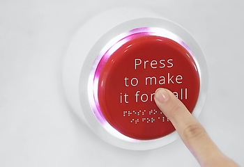
Within the Haltebuddy application the users can view what bus, tram, and train stops are accessible for their personal situation. The application asks you if you travel by, for instance, an electric wheelchair, a manual wheelchair, walking sticks, or crutches. In addition, you can enter the width you need to enter and leave the vehicle; how high a threshold or the height to a vehicle can be; and if you want to use a ramp at higher thresholds. After answering those questions you can see what stops are accessible to you, keeping your personal situation and preferences in mind. We also incorporated a ‘’Stop Button’’, which allows you to let the public transport staff know that you are coming and need extra help or time when boarding.
Bron: Amsterdam Intelligence
What is the difference between the Haltebuddy application and the function on the GVB application?
They are almost the same. Although, we developed the Haltebuddy application to display the possibilities. Transport organizations can copy the functionality to improve the travel advice within their applications for people with disabilities. We have included the source code and technical documentation onour landing pageto facilitate this. Therefore, the Haltebuddy app is not developed to be a long-term solution of its own.
‘’It is developed to show what is possible to others so that they can implement these features themselves''.
We also asked the GVB to make the data API open source, so that others can easily use it. In addition, there is also someone at the Amsterdam Transport Authority that can help others to implement the same function.
Were there any complications during the Haltebuddy project?
Everything went pretty smooth and fast. The developers at GVB could fairly easily write our code into the GVB app. However, the biggest challenge is to translate it to a full travel advice function on the GVB app. For that a change is needed in the routing API they use. It’s on their roadmap however!
How is the application received by its users?
Quite good. We tested it with the UX lab from the municipality. The test group shared their experience during the use of the app. One of the users understood the Haltebuddy application less well than the others, but most of them were happy with the Haltebuddy application. The GVB also did a test for the function within the GVB application. The most exciting question is if the reality is in line with the data, the best way to find that out is by letting people use the Haltebuddy application and the function on the GVB application.
Summed up,we developed the Haltebuddy application to prove that you can successfully match data about people’s individual requirements with the available data about the physical aspects of public transport within Amsterdam. We found the GVB willing to implement some of these functions into their app. We hope this makes planning for regular public transport a bit more accessible for people with disabilities.