Welcome everyone to the final presentations of the DRSR working group. Today, we embark on a journey that has spanned over the last eight years, exploring innovative ways of working with data and the new questions these methods enable us to address. We are delighted to have a diverse group of participants here, each bringing unique perspectives from policy, research, and everyday experiences.
Our session will involve breaking into smaller groups to delve into four distinct methodologies we've studied. Through this collaborative effort, we aim to understand the types of questions each methodology can help us answer, fostering a richer interdisciplinary dialogue. Remember, there are no wrong questions or comments today—everything is an opportunity to learn.
Our team has worked tirelessly to prepare for this event, often coordinating across different continents and time zones. Special thanks to our colleagues joining us remotely from countries like Russia, India, Israel, and Montenegro. We are grateful for their invaluable contributions.
We start today with a focus on artistic research, which is foundational to our work on trust and presence in digital systems. This work is crucial as we continue to navigate the complexities of integrating human trust with technological systems. Let's begin our exploration and engage fully in this collaborative journey.
Recorded and edited by Thijs van Schijndel with assistance of otter A.I. and ChatGPT4.0
The Healthy Living department of Amsterdam, located at the Public Health Service, collaborates closely with the CSO on innovative projects. Despite challenges like COVID-19, they continue to develop unique ideas, such as the photographic project on global food movement presented at the maritime museum. Karen highlights making complex concepts accessible for public servants, using innovative data algorithms to enhance trust and public health. Today's session aims to inspire participants from various domains to explore how these insights can shape future policies and improve life in Amsterdam. The goal is to use data effectively to integrate infectious disease prevention with broader public health initiatives, ensuring a healthier city for all.
The Healthy Living department of the city of Amsterdam, based at the Public Health Service, has a long-standing collaboration with Caroline Nevejan. This partnership is built on innovative and creative ideas that aim to improve the city's health and well-being. Despite the logistical challenges posed by COVID-19, their work continues to thrive. One notable project born from this collaboration is a photographic exhibition on the global movement of food, displayed at a local skate park. This initiative started with Kadir, an artist stuck in Amsterdam, whose idea was supported by Caroline and her colleagues, turning it into a significant event.
Caroline’s approach often involves bringing together diverse minds over coffee to brainstorm groundbreaking projects. One such initiative during the pandemic involved Pinar, a PhD student who also contributed to Amsterdam's Corona prevention team. Pinar’s unique perspective and ability to ask insightful questions significantly enriched the team's efforts, highlighting the value of interdisciplinary collaboration.
The team's strength lies in making complex ideas and data accessible and practical for public servants. They developed algorithms that brought data to life, helping to build trust and improve public health strategies. For example, the team used the UPA framework to address trust issues during COVID-19. Despite initial skepticism about the practical applications of their research, the outcomes have been impressive, with innovative algorithms providing new insights into public health.
Today's session aims to inspire participants from various fields, encouraging them to explore how these insights can shape future policies and improve life in Amsterdam. The goal is to use data effectively, integrating infectious disease prevention with broader public health initiatives. This includes identifying which datasets are most useful and how they can be applied to enhance the city's health services.
A practical example of this approach is the adjustment of traffic light timings to better accommodate the elderly and those with mobility challenges. By making such small but impactful changes, the team demonstrates how thoughtful data application can lead to significant improvements in daily life.
The session also aims to highlight the importance of understanding rhythms in urban life. By focusing on rhythms, the team believes they can foster a better, more livable city. They encourage participants to embrace creativity and open-mindedness in exploring how these concepts can be applied in their work.
Looking ahead, the team envisions using their findings to inform policy and improve public health initiatives. They emphasize the importance of continued collaboration and innovation, ensuring that Amsterdam remains a healthy and vibrant city for all its residents. The session will conclude with reflections on how this type of work can address current challenges and shape future efforts.
Recorded and edited by Thijs van Schijndel with assistance of otter A.I. and ChatGPT4.0
In today's session, we explore how rhythms and interactions shape our social environments. We begin with an example of how familiarity can emerge from shared activities like walking dogs or shopping, leading to meaningful social connections. Sudesh Kumar's work on rhythms highlights the circular nature of wisdom, showing its presence from the smallest particles to the stars. This concept connects our natural and social worlds, emphasizing the importance of cultural and rhythmic harmony. We learn how urban data and rhythmic analysis can inform policy, improving everyday life through practical solutions like adjusting traffic lights for the elderly. Our interdisciplinary approach integrates artistic research, data science, and qualitative methods to understand and enhance the rhythms of urban living, fostering trust and collaboration. Today's goal is to explore these methodologies to create more inclusive and responsive urban policies.
Today, we delve into the interplay of rhythms and interactions that shape our social environments. We begin with a simple yet profound observation: familiarity can emerge from shared activities such as walking dogs or shopping, leading to meaningful social connections. This concept is exemplified by Sudesh Kumar's work on rhythms, which highlights the circular nature of wisdom. He demonstrates how rhythms are not linear but circular, connecting the smallest particles to the vast cosmos. This circularity is foundational to our understanding of both natural and social worlds, underscoring the importance of cultural and rhythmic harmony.
Wisdom, or "vism," as Sudesh terms it, connects the natural world with the social world. Anthropologists confirm that rhythms are integral to all cultures, linking people to their environment and marking significant events like the shortest day of the year. This interconnectedness is also evident in modern urban life, where traffic lights, social routines, and even digital interactions create a complex web of rhythms.
One of the key learnings from our artistic research is the concept of "entrainment" – the synchronization of rhythms. For instance, when two people walk together, they naturally fall into step. This ability to tune into each other's rhythms is fundamental to building trust in society. It happens in physical spaces as vibrations and patterns and extends to our social interactions, both online and offline.
This rhythmic understanding informs our approach to urban planning and policy-making. For example, we discovered that elderly residents were not using a park because the traffic light timing didn't allow them enough time to cross the street. By adjusting the timing, we enabled them to access the park, demonstrating how small changes can have significant impacts. Similarly, we found that single mothers were not accessing available financial support because of the intimidating process at city hall. By moving the application process to community centers, we created a more welcoming environment.
Our interdisciplinary approach combines artistic research, data science, and qualitative methods to explore and enhance urban rhythms. This led to the development of a framework for "citizen data ecology," recognizing that data created by people, whether digital or not, influences policy and behavior. Policymakers often view the world linearly, but our research shows the importance of cyclical processes and the need for policies that reflect this reality.
We also explored the integration of quantitative and qualitative data, creating visualizations that help decision-makers understand complex information. For instance, using data from mobile phones and social networks, we could map urban rhythms and identify areas for intervention. This approach allowed us to make informed decisions, such as optimizing traffic light timings and improving public spaces.
Our work emphasizes the aesthetic and practical importance of sharing rhythms. Whether in collaborative work settings or individual activities, shared rhythms create energy and foster engagement. This understanding is crucial for developing inclusive urban policies that respond to the needs of diverse communities.
Today's session aims to further explore these methodologies, focusing on how we can apply them to create more inclusive and responsive urban policies. By understanding and harnessing the power of rhythms, we can enhance our social environments, foster trust, and build stronger, more connected communities.
Scott Cunningham discusses applying algorithms to address social cohesion issues in Scotland, similar to methods used in the Netherlands. Following Brexit and COVID-19, he argues that good data and better models can foster inclusive growth in Scotland. Scott introduces the "pull-up model," emphasizing an ecological view of data, encompassing population, organization, environment, and technology layers. He highlights the importance of institutional economics in understanding spatial and social patterns. Using Scottish census data, Scott illustrates how socio-economic factors influence living conditions and access to opportunities. He presents a case study on electric vehicle charging infrastructure to show spatial disparities in technology access. Despite challenges like outdated census data, Scott advocates for innovative methods like machine learning to better understand and address social inequalities. The session aims to explore these insights to inspire future policies and improve life in Scotland.
Scott Cunningham’s presentation focuses on using data and algorithms to tackle social cohesion issues in Scotland, drawing parallels with methods used in the Netherlands. After moving from the Netherlands to Scotland, Scott observed significant socio-political changes, including Brexit and COVID-19, which have impacted social cohesion. He argues that improved data and models can promote inclusive growth in Scotland, a key national agenda.
Scott introduces the "pull-up model," an ecological framework for understanding cities that incorporates four layers: population, organization, environment, and technology. This model, learned at an AMS conference, allows for a comprehensive analysis of how these layers interact. Scott collaborates with Strathclyde's urban design unit, Urban Morphometrics, focusing on spatial structures and clustering within cities. His work integrates these insights with his role as a policy analyst to explore the interplay between human populations and technological environments.
Institutional economics, according to Scott, provides a lens to understand how rules—whether legal, cultural, or self-imposed—shape social and spatial patterns. He uses Scottish data to illustrate these concepts, emphasizing how administrative structures influence data collection and use. The Scottish census organizes data zones to provide a detailed national overview, reflecting the complex political geography of Scotland, a devolved part of the UK with its own budgetary authority in areas like healthcare.
Scott’s data analysis reveals stark contrasts in socio-economic opportunities across Scotland. For example, maps of deprivation zones show significant disparities within short distances, such as between affluent areas and deprived zones in Glasgow. These patterns highlight long-standing issues like pollution and lack of economic opportunities in certain areas, perpetuating social inequalities.
One case study Scott presents involves electric vehicle (EV) charging infrastructure in Scotland. While EVs are seen as a clean and sustainable technology, their adoption faces challenges, especially in remote areas. Publicly owned charge points leased to small enterprises often result in higher costs for remote regions due to installation logistics. This example underscores the spatial disparities in access to sustainable technologies.
Scott advocates for the use of machine learning and innovative data analysis methods to address these inequalities. By recognizing patterns in census data and other demographic information, policymakers can better understand and address social issues. For instance, identifying urban potentials—demographic types based on neighborhood characteristics—can inform targeted interventions.
Scott also discusses the limitations and challenges of using census data, such as outdated information and the need for supplementary data sources like retail data or mobile phone data to accurately capture population dynamics. Despite these challenges, he emphasizes the importance of understanding spatial and social textures to inform urban planning and policy decisions.
In conclusion, Scott’s presentation highlights the potential of advanced data analysis to address social cohesion issues in Scotland. By integrating ecological models, institutional economics, and innovative data techniques, policymakers can develop more inclusive and effective strategies. The session aims to inspire participants to apply these insights in their work, ultimately improving social cohesion and quality of life in Scotland.
Recorded and edited by Thijs van Schijndel with assistance of otter A.I. and ChatGPT4.0
Alessandro Bozzon discusses the role of AI in public decision-making, emphasizing the need for interdisciplinary approaches that integrate sociology, psychology, and urban sciences. He highlights the importance of designing AI systems that are fit for purpose from the start, rather than dealing with consequences later. Bozzon stresses the necessity of contestability in AI, allowing public participation and feedback throughout the system's lifecycle to ensure fairness, legitimacy, and alignment with societal values.
In his presentation, Alessandro Bozzon delves into the integration of AI in public decision-making, exploring its potential and challenges. He begins by introducing himself as a computer scientist working within the Faculty of Industrial Design Engineering. Bozzon emphasizes the importance of interdisciplinary approaches in developing AI systems, incorporating insights from sociology, psychology, and urban sciences. His primary focus is on public AI, which utilizes predictive and descriptive models to support decision-making and policy implementation in the public sector.
Bozzon explains that public AI involves algorithms that interact with real-world data, influencing human lives and creating an ecology of diverse agents and actors, including humans and AI systems. He illustrates this with examples like traffic systems, where smart traffic lights and autonomous cars negotiate the flow of traffic, affecting human behavior and urban rhythms. He highlights the subtle ways in which autonomous systems, such as AI-enabled trash collection or Airbnb monitoring, impact societal routines and policies.
A key theme in Bozzon's presentation is the need for designing AI systems that are purpose-fit from the start, rather than creating technology first and addressing its consequences later. He advocates for a methodology where the design process begins with a clear understanding of the desired outcomes and the contextual realities of the environment in which the AI will operate. This approach acknowledges the limitations of data, emphasizing that data is always an approximation of reality, not a perfect representation.
Bozzon introduces the concept of "contestable AI," which is AI that is open to dispute and feedback throughout its lifecycle. This involves creating systems that are transparent and responsive to public input, ensuring that the systems align with societal values and are perceived as legitimate by those affected. He discusses the importance of involving citizens, policymakers, and developers in the design and monitoring of AI systems, expanding the traditional loops of interaction and making the process more democratic and inclusive.
He provides a practical example with the camera car used for monitoring traffic and public spaces. Bozzon explains how such systems, when designed with contestability in mind, can be more responsive and fair, as they allow for public participation in their development and operation. This participatory approach helps bridge the gap between the digital and physical worlds, ensuring that AI systems do not disrupt but rather enhance societal functions.
Bozzon also touches on the ethical and technical complexities of implementing public AI. He emphasizes the need for rich methodological portfolios that combine ethnographic and data-driven research to understand and predict human behavior accurately. This interdisciplinary approach helps create AI systems that respect and integrate the values, rhythms, and properties of the communities they serve.
In conclusion, Bozzon underscores the importance of contestability as a core property of public AI systems. He argues that making AI systems open to dispute and responsive to public input not only increases their perceived legitimacy but also ensures they are better aligned with societal needs and values. He calls for a shift from merely building advanced models to focusing on problem formulation, system design, and the integration of diverse perspectives in the AI development process. Bozzon's vision for public AI is one where technology serves the public good, operating transparently and democratically, with continuous feedback and improvement based on public participation.
Recorded and edited by Thijs van Schijndel with assistance of otter A.I. and ChatGPT4.0
Achilleas Psyllidis discusses the rhythms of urban mobility and access, using data from the COVID-19 period to illustrate changes. While personal mobility decreased during the pandemic, the need for goods and services remained, shifting mobility patterns. Bozzon’s team examined the feasibility of maintaining social distancing in dense urban environments by analyzing sidewalk widths and street centrality. They developed a dashboard to assess the risk of close encounters in Amsterdam. Additionally, the City Walk map tool was created to measure potential social encounters and accessibility to various amenities within walking distances. This tool also evaluates the diversity of users accessing these places, offering insights into urban planning and public health. Psyllidis emphasizes the importance of understanding how different places facilitate social interactions and the potential for infectious disease spread. His research aims to inform policies for more resilient and inclusive urban environments.
Psyllidis's presentation on the rhythms of urban mobility and access focuses on how mobility patterns were altered during the COVID-19 pandemic. He begins by contrasting the drastic reduction in personal mobility with the sustained need for goods and services, leading to a shift where goods were delivered to people instead of them going out. This change highlighted the importance of access and connectivity, showing that while mobility decreased, the demand for access remained constant.
Psyllidis's team delved into the specifics of urban mobility during the pandemic, noting significant changes such as a 23% decrease in public transport use and an 8% increase in car use. Walking, in particular, saw a 59% increase as people sought to access nearby services and amenities. This shift underscored the inequality in access within cities, where some people had many amenities within walking distance, while others had few.
To address these issues, Psyllidis’s team developed tools to assess and improve urban mobility and access. One key tool was a dashboard analyzing the feasibility of maintaining social distancing on sidewalks. By examining sidewalk widths and the centrality of streets in Amsterdam, the team could identify areas where social distancing was difficult to maintain. This analysis showed that while some streets allowed easy social distancing, many did not, highlighting the challenges of dense urban environments.
Another significant development was the City Walk map tool, which measures the potential for social encounters and access to amenities within walking distances. This tool evaluates not just the number of accessible places but also the diversity of people who can access them. For example, it can show whether different age groups or socio-economic backgrounds are likely to use the same park or public space. This information is crucial for urban planning and public health, as it helps identify areas where people from different walks of life can come together, as well as potential hotspots for disease transmission.
Psyllidis emphasizes that understanding the spatial and social dynamics of urban environments is vital for creating resilient cities. The tools developed by his team provide insights into how urban spaces can facilitate or hinder social interactions and access to services. For instance, the analysis of potential social encounters can inform strategies to enhance social cohesion and mitigate the spread of infectious diseases.
In addition to these tools, Psyllidis discusses the broader implications of his research for urban planning. By integrating data on mobility, access, and social interactions, policymakers can better design cities that are inclusive and adaptable to changing circumstances. This approach aligns with the goal of creating cities that are not only efficient but also equitable, ensuring that all residents have access to essential services and opportunities for social interaction.
Psyllidis's research highlights the importance of a holistic view of urban mobility and access, considering both physical infrastructure and social dynamics. His team's innovative use of data and analytical tools provides a model for other cities looking to improve their resilience and inclusivity. By understanding and leveraging the rhythms of urban life, cities can better prepare for future challenges and create environments that support the well-being of all residents.
Recorded and edited by Thijs van Schijndel with assistance of otter A.I. and ChatGPT4.0
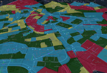
Katya Letunovsky’s presentation focuses on using space-time data to visualize urban mobility patterns. Inspired by Swedish time geography, her team at Habidatum developed the chronotope system to analyze aggregated data, respecting privacy standards. This 3D visualization tool overlays static maps over time, forming a spatial-temporal volume. An example includes analyzing the overlap of tourists and locals in Barcelona to identify crowded periods and areas. Another application involved monitoring changes in mobility patterns during the COVID-19 pandemic, highlighting areas with significant changes in movement. The research integrates qualitative and quantitative data to understand the dynamics of community networks and the impact of events like football matches. By identifying key metrics such as frequency of visits and duration of stays, the team aims to enhance urban planning and public health strategies. The approach provides valuable insights into how different urban spaces are used and how they can be improved.
Katya Letunovsky’s presentation discusses the use of space-time data to analyze urban mobility and social interactions. Inspired by Swedish time geography, which visualizes individual activities over time in a 3D space, her team sought to adapt this concept to aggregated data while maintaining privacy standards. This led to the development of the chronotope system, which layers static maps over time to create a spatial-temporal volume that can be analyzed in various ways, such as by location or time period.
One notable application of the chronotope system was in Barcelona, where the team used it to study the interactions between tourists and locals. By examining social media data and mobile phone movements, they could identify times and places with high concentrations of both groups, highlighting potential areas of tension. This analysis helped visualize the impact of tourism on local communities, particularly during peak commuting times.
During the COVID-19 pandemic, the chronotope system proved invaluable for monitoring changes in mobility patterns. The Mobility Monitor tool was developed to show how people’s movements and dwell times in different city areas changed over time. For instance, areas with severe lockdown restrictions showed less movement, while others with lighter restrictions had more active streets. This visualization used color coding to indicate changes, with blue representing less change and brown indicating more significant changes. This tool provided insights into how different areas adapted to lockdown measures and where people were still moving actively.
In addition to mobility patterns, the team explored the impact of events on urban environments. By analyzing data before, during, and after events such as football matches, they could visualize how crowds gathered, dispersed, and moved across the city. This information is crucial for event planning and managing urban spaces during significant gatherings, helping to ensure smooth and safe movement of people.
The research also integrated qualitative methods from ethnographic studies to enhance the understanding of community dynamics. By identifying key metrics such as the frequency of visits, duration of stays, and proximity to home, the team developed a comprehensive map of community networks and important local spaces, referred to as "foams." These foams represent places that matter to local communities, needing frequent and substantial visits and being located near people's homes.
The combined approach of qualitative and quantitative data analysis provides a richer understanding of urban mobility and social interactions. For example, the team’s analysis of changes in infection rates over time, combined with mobility data, allowed them to map areas with high and low social interaction, informing public health strategies and urban planning.
By using the chronotope system and the concept of foams, the research provides valuable insights into how urban spaces are utilized and how they can be optimized for better social interactions and public health outcomes. The goal is to create more resilient and inclusive urban environments that cater to the needs of diverse populations.
Katya’s work underscores the importance of integrating different types of data and methodologies to understand the complexities of urban life. The innovative use of space-time data visualization offers a powerful tool for urban planners and policymakers, enabling them to make informed decisions that enhance the livability and functionality of cities.
Recorded and edited by Thijs van Schijndel with assistance of otter A.I. and ChatGPT4.0
Participants engaged in discussions about urban mobility, public health, and data analysis, emphasizing the integration of various data types to inform policy-making. Key insights revolved around improving accessibility, combining qualitative and quantitative methods, and fostering collaboration.
Discussion kick-off by Caroline Nevejan:
conclusion by Jeroen Slot and Karen den Hartog:
Summary of workshop findings:
Inspiration and Validation
Discussions provided both inspiration and concrete validation for the methods explored.
Participants highlighted the need for clear metrics and models to better understand urban dynamics.
Challenges and Opportunities
Difficulty in aligning monitoring data with real-world experiences was noted.
The potential of models to reveal unseen aspects of population insights and undercurrents was emphasized.
Application in Practice
Practical applications discussed included using accessibility data to improve city planning and public health.
Participants explored how interventions can be designed to reach specific populations, such as children needing vaccinations or lonely individuals.
Integration of Different Data Types
Combining individual and aggregate data was identified as crucial for effective analysis.
Discussions covered the balance between detailed individual data and broader system-level insights.
Methodological Insights
The importance of dwelling time and the ability to explore data creatively was stressed.
Participants noted the necessity of showing different rhythms (spatial, temporal, functional) to policymakers.
Policy and Intervention Design
The impact of urban policies on spatial-temporal segregation was discussed.
Methods to balance the benefits and risks of social encounters, especially during pandemics, were explored.
Collaborative Efforts
The importance of collaboration between municipalities, academic institutions, and private partners was highlighted.
Participants noted that a combination of expertise is needed to leverage data effectively and address legal issues.
Future Directions
Discussions about how to integrate new data sources and methodologies into existing frameworks were prominent.
The session concluded with a call for continued collaboration and creative exploration to tackle urban challenges.
wrap up archillis:
Wrap up scott
Final Remarks
Participants expressed appreciation for the collaborative nature of the session.
There was a consensus on the need to continue exploring these methodologies to inform urban planning and public health policies.
The session ended with a commitment to follow up on the discussions and integrate the insights gained into future projects.
wrap up: group 3
wrap up: group 2
wrap up group 1:
Recorded and edited by Thijs van Schijndel with assistance of otter A.I. and ChatGPT4.0