Collectie
(14)
-
Artikel
Aqueduct 4.0: Updated Decision-Relevant Global Water Risk Indicators
Deze technische nota dient als belangrijkste referentie voor het bijgewerkte Aqueduct™️ 4.0 waterrisicoframework. Het beschrijft de gegevens en methodologie die zijn gebruikt om 13 indicatoren van het mondiale waterrisico te creëren. Indicatoren weerspiegelen zowel de huidige omstandigheden als toekomstige projecties van het wateraanbod, de vraag, stress en meer. Dit document beschrijft ook hoe waterrisico's kunnen worden samengevoegd in risicocategorieën, zoals fysiek en kwaliteitsrisico, maar ook in administratief risico.
-
Artikel
AqueductTM Water Risk Atlas (Aqueduct 3.0)
In August 2019, WRI released an updated version of the AqueductTM Water Risk Atlas (Aqueduct 3.0). This document provides information on what’s new in Aqueduct 3.0 (Part I) and explains why it matters by comparing results with those available in the old version of the tool (Aqueduct 2.1) (Part II).
Source: Aqueduct What's New
-
Artikel
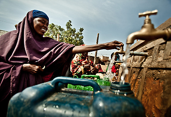
Water, Security, and Conflict
Water has played a key role in human security throughout history, but attention to water-related threats has been growing in recent years due to increasing water risks. Water demand has increased sharply in many regions of the world as a result of population growth and economic expansion. Water supply is expected to decline in the mid-latitude regions of the world because of climate change, which is also expected to alter the timing of water availability and increase the severity of drought and flood events.
The destruction of natural habitat and the discharge of untreated municipal, industrial, and agricultural wastewater into our rivers and lakes is rendering much of our surface water and groundwater unusable. These increasing pressures on water resources are undermining water security and contributing to conflict, migration, and food insecu- rity in many parts of the developing world.
Source: Gleick, P., & Iceland, C. 2018. Water, Security, and Conflict. World Resource Institute.
-
Artikel
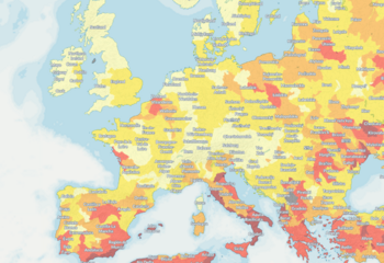
Baseline Water Stress: China
The Aqueduct Water Risk Atlas, developed by the World Resources Institute (WRI), evaluates, maps, and scores water risks globally based on 12 indicators, including baseline water stress. Baseline water stress measures the ratio between total water withdrawal and available renewable surface freshwater supply, and is a good proxy for water risks more broadly. The atlas calculates baseline water stress based on country-level water withdrawal data from the Food and Agriculture Organization of the United Nations, spatially disaggregated by sector into Aqueduct’s catchment areas. Where available, however, more detailed data allow the development of a baseline water stress map for a country or region. In the case of China, freshwater withdrawal data at the prefecture level provide more accurate information, such as spatial patterns, that are otherwise lost in the aggregated country-level statistics.
Source: Wang, J., L. Zhong, and Y. Long. 2016. “Baseline Water Stress: China.” Technical Note. World Resources Institute, Beijing. Available online.
-
Artikel
Volumetric Water Benefit Accounting (VWBA)
Volumetric water benefits (VWBs) are the volume of water resulting from water stewardship activities, relative to a unit of time, that modify the hydrology in a beneficial way and/or help reduce shared water challenges, improve water stewardship outcomes, and meet the targets of Sustainable Development Goal 6.
Source: Reig, P., W. Larson, S. Vionnet, and J.B. Bayart. 2019. “Volumetric Water Benefit Accounting (VWBA):
A Method for Implementing and Valuing Water Stewardship Activities.” Working Paper. Washington, DC: World Resources Institute. Available online. -
Artikel
Managing public water management by harmonizing and sharing corporate water risk information
In response to water crises across the globe, data on biophysical conditions associated with water risk have increasingly been collected and understood. However, a complete assessment of water risk also requires an understanding of public water manage- ment. Currently there is a lack of global compa-
rable data on public water management, leading to incomplete assessments of risk and suboptimal risk mitigation activities.To fill in that gap in data, this Technical Note proposes the creation of a global comparable geodatabase of public water management indicators to spur tangible improvements in water management. The geodatabase will be populated by crowdsourcing data through the risk assessments of multinational companies that are incentivized to share anonymized public water management as an innovative risk reduction practice.
Source: Kölbel, J., Strong, C., Noe, C., Reig, P. 2018. “Mapping Public Water Management by Harmonizing and Sharing Corporate Water Risk Information.” Available online.
-
Artikel
Setting Site Water Targets Informed By Catchment Context
The world’s water resources are under growing pressure from rising water consumption, greater pollution, weak governance, and climate change—exposing companies to increased water-related risks. In response, many companies are engaging in water stewardship and setting water targets to help address their water- related externalities and secure water for the growing needs of all users.
Site water targets informed by catchment context have an important role to play in addressing water challenges and driving informed actions at the local level. Yet a minority of companies are setting them.2
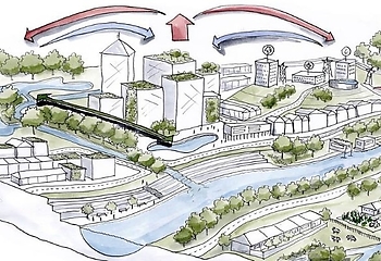
This guide aims to help companies set effective site water targets that are informed by catchment context, which can create value and lessen risks for the company and support collective action. This guide is intended for site staff or technical water specialists responsible for water management, and relevant corporate staff. This guide lays out three key elements for setting effective site water targets:
-
Water targets should respond to priority water challenges within the catchment;
-
The ambition of water targets should be informed by site’s contribution to water challenges and desired conditions; and
-
Water targets should reduce water risk, capitalize on opportunities, and contribute to public sector priorities.
-
-
Artikel
Mapping Public Water Management
Many water crises are, at their root, crises of water gover- nance and management. To effectively respond to water crises driven by governance and management failures, there is a need for empirical, comparable, global informa- tion on the state of public water management.
In an effort to fill this data gap, this technical note tests
a novel data collection approach that relies on crowd- sourcing data from multinational enterprises with opera- tions across many geographies. The approach was piloted with six contributing multinational companies, and the results were validated in eight locations in the regionof Southern California (United States) and the state of Maharashtra (India).
The pilot study suggests that the new data collection approach is scalable and has the potential to generate a global dataset of public water management capacity. The field validation exercise suggests that the collected data are mostly viewed as valid by local experts and stakehold- ers, but the exercise also identifies a number of weak- nesses. Based on these findings, this paper presents an updated survey that improves upon the original survey used in the pilot study.
Source:
Logg, C., J. Kölbel, C. Strong, P. Reig, and R. Hamilton. 2020. “Mapping Public Water Management: Proof of Concept.” Technical Note. Washington, DC: World Resources Institute. Available online.
-
Artikel
Leveraging Water Data in a Machine Learning–Based Model for Forecasting Violent Conflict
We present a methodology to forecast conflict (defined as organized violence resulting in at least 10 fatalities over a 12-month period) up to a year in advance using a random forest model. When applied to test data, the model captures 86 percent of future conflicts. The model’s conflict signal is noisy, with half of conflict predictions representing false positives.
We also explore whether water-related indicators are useful predictors of conflict. Water-related variables are assessed to be correlated with conflict outcomes, but not empirically significant for model decision-making. However, adjusting the definition of conflict, such as by lowering the fatality threshold or examining only emerging conflict, increases the signifi- cance of water variables. A web-based tool that houses the model allows users to explore forecasts and indicators spatially and through time, providing additional informa- tion on underlying vulnerabilities as a first step toward enabling timely, effective water-related interventions to mitigate conflict and/or build peace.
Source: Kuzma, S., P. Kerins, E. Saccoccia, C. Whiteside, H. Roos, and C. Iceland. 2020. “Leveraging Water Data in a Machine Learning–Based Model for ForecastingViolent Conflict.” Technical Note. Washington, DC: World Resources Institute. Available online.
-
Artikel
Aqueduct Floods Methodology
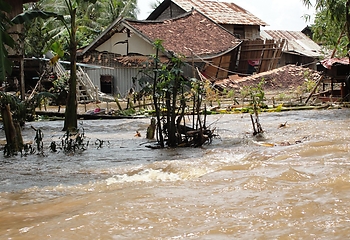
Flooding is among the most serious and dangerous of all global risks, causing loss of life and damage to property, livelihoods, and economies. Flooding is also likely to intensify in the coming decades due to climate change. Additionally, economic growth and urbanization are putting more and more assets and people into flood-prone areas. Despite these dangers, flood risks are often under- estimated and poorly managed due to the lack of data and actionable information, particularly in less-developed regions.
Aqueduct Floods is an online platform that measures riverine and coastal flood risks under both current base- line conditions and future projections in 2030, 2050, and 2080. In addition to providing hazard maps and assess- ing risks, Aqueduct Floods enables its users to conduct comprehensive cost-benefit analysis to evaluate the value of dike flood protection strategies.
Aqueduct Floods aims to empower disaster risk analysts and managers with quantitative information on flood risks and adaptation strategy costs, and to help inform policy and investment decision-making. This technical note explains in detail the framework, methodology, and data used in developing Aqueduct Floods to help users better interpret the risk information presented on the tool and understand the full strength and limitations of our data and methodology.
Source: Ward, P.J., H.C. Winsemius, S. Kuzma, M.F.P. Bierkens, A. Bouwman, H. de Moel, A. Díaz Loaiza, et al. 2020. “Aqueduct Floods Methodology.” Technical Note. Washington, D.C.: World Resources Institute. Available online.
-
Artikel
Aqueduct 3.0: Updated Decision-Relevant Global Water Risk Indicators
Water is essential to the progress of human societies. It is required for a healthy environment and a thriving economy. Food production, electricity generation, and manufacturing, among other things, all depend on it.
However, many decision-makers lack the technical expertise to fully understand hydrological information. In response to growing concerns from the private sector and other actors about water availability, water quality, climate change, and increasing demand, WRI applied the composite index approach as a robust communication tool to translate hydrological data into intuitive indicators of water-related risks.
Source: Hofste, R., S. Kuzma, S. Walker, E.H. Sutanudjaja, et. al. 2019. “Aqueduct 3.0: Updated Decision- Relevant Global Water Risk Indicators.” Technical Note. Washington, DC: World Resources Institute. Available online.
-
Artikel
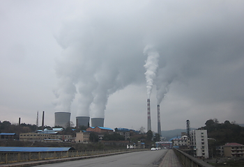
Parched Power: Water Demands, Risks, and Opportunities for India’s Power Sector
India’s thermal power sector is very dependent on water and has been suffering from water shortages, losing a substantial part of its generation growth every year since 2013. Most
of the country’s existing plants are likely to experience an increased level of water competition by 2030.Source: Luo, Tianyi, Deepak Krishnan, and Shreyan Sen. 2018. “Parched Power: Water Demands, Risks, and Opportunities for India’s Power Sector.” Working Paper. Washington, DC: World Resources Institute. Available online.
-
Artikel
A Methodology to Estimate Water Demand for Thermal Power Plants in Data-Scarce Regions Using Satellite Images
Thermal power plants depend on and consume water for cooling. Detailed power sector water-use data can help aid in evaluating the security of water access for power plants as well the impact of their water use on downstream water users. While power generation data are widely available globally, no readily available global data exist on power plant water withdrawal and consumption. This paper proposes an innovative methodology to help close the power sector water-use data gap for data-scarce regions.
The methodology uses free, easily accessible satellite images to visually identify cooling and fuel type, and empirical water-use factors to estimate water demand. The method was tested against 200 U.S. power plants
and achieved 90 percent precision in cooling technology identification, 89 percent precision in fuel identification, and 69 percent precision in water demand estimation. Information gleaned from this methodology can be used by companies, investors, and the general public to better understand water risks to energy and to devise a better path forward.
Source: Luo, T., A. Krishnaswami, and X. Li. 2018. “A Methodology to Estimate Water Demand for Thermal Power Plants in Data-Scarce Regions Using Satellite Images.” Technical Note. Washington, DC: World Resources Institute. Available online.
-
Artikel
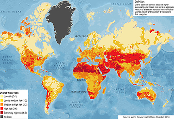
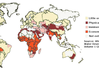
Kwart wereldbevolking loopt extreem risico op gebrek aan water
Extreme droogte in onder meer India en Zuid-Afrika laat zien hoeveel impact een tekort aan water kan hebben. Uit nieuw onderzoek blijkt dat een kwart van de wereldbevolking in landen woont met een extreem hoog risico op waterschaarste. Dit onderzoek is verzameld in de nieuwe Waterrisico-atlas externe link van het World Resources Institute die deze week is gepubliceerd. Hydrologen van de Universiteit Utrecht leverden met hun berekeningen de basis voor de atlas.
In de landen met een extreem hoog risico op waterschaarste wordt gemiddeld 80% van het beschikbare hernieuwbare water gebruikt in een jaar. Er zijn dus weinig reserves en de druk op een alternatieve bron zoals grondwater is hoog. Als er veel vraag naar water is, kunnen zelfs korte perioden van droogte grote gevolgen hebben. Die verhogen het risico op een acuut watertekort zoals in Kaapstad, Zuid-Afrika, in 2018 en nu in Chennai, India. Dit risico is volgens de nieuwe berekeningen extreem hoog voor zeventien landen, die samen een kwart van de wereldbevolking huisvesten.
Serieuze bedreiging
Een gebrek aan water vormt een serieuze bedreiging voor mensen, dieren en de natuur. Het kan ernstige gevolgen hebben voor voedselzekerheid en kan conflict en migratie veroorzaken of versterken. Door klimaatverandering en een groeiende wereldbevolking zal waterschaarste in de toekomst alleen maar verder toenemen.
Hydrologisch model als basis
Het mondiale hydrologische model PCR-GLOBWB van de Utrechtse hydrologen vormt de basis voor de indicatoren in de atlas die inzicht bieden in de huidige en toekomstige stand van waterbronnen en hun gebruik. Met het model konden de wetenschappers de watervraag, de beschikbaarheid van oppervlakte- en grondwater en de resulterende wateronttrekkingen berekenen voor cellen van het aardoppervlak van 10 bij 10 km.
Ecologische schade voorkomen
Doordat alle data nu op dezelfde resolutie beschikbaar en met hetzelfde model berekend zijn, kunnen de verschillende indicatoren van waterschaarste nu onderling vergeleken worden. Dit laat niet alleen zien waar de druk op hernieuwbare waterbronnen groot is, maar ook waar de grenzen van duurzaam gebruik al overschreden zijn en grondwaterreserves uitgeput raken. Dit is onder meer het geval in het Midden-Oosten en Noord-Afrika, waar de huidige schaarste in de toekomst nog nijpender zal worden. “In deze gebieden moeten we op zoek naar duurzamere oplossingen om ecologische schade verder te voorkomen en mensen op lange termijn voldoende bestaanszekerheid te bieden,” zegt hydroloog dr. Rens van Beek externe link, een van de Utrechtse hydrologen. Samen met prof. dr. Marc Bierkens externe link, dr. Yoshihide Wada externe linken dr. Edwin Sutanudjaja externe linkvormde hij Utrechtse atlasteam.
Met hun hydrologische model konden zij eerder al de wereldwijde overstromingsrisico’s in kaart brengen en de grenzen aan het oppompen van grondwater bepalen.
Onderzoekspartners
De ontwikkeling van de data voor de World Risk Atlas deden de Utrechtse hydrologen als onderzoekspartners van het World Resources Institute samen met collega’s van de TU Delft, Deltares, het Instituut voor Milieuvraagstukken (IVM), het Planbureau voor de Leefomgeving (PBL) en RepRisk.
Bron: Universiteit Utrecht - Kwart wereldbevolking loopt extreem risico op gebrek aan water
Klik hier voor de Waterrisico-atlas